No Turn On Red

No Turn On Red

Thursday, June 19, 2025

Grand Canyon National Park - North Rim

Sunday, 25 May, and Monday, 26 May 2025

Only about 10% of visitors to the Grand Canyon make it to the North Rim. It is 1000 ft higher in elevation, so is considerably cooler, and the road is closed during the winter (December 1 to May 14). It is a different perspective than the South Rim.

View from Lodge terrace. The San Francisco Peaks are visible in the distance.

Sunset illuminates the far rim.

A wider sunset view.

Sue on the Bright Angel Point trail. There's a reason that Grand Canyon tops the national parks list for fatalities - there's very little protection from stupid moves.

A vintage photo from 1988. This is the South Rim, but you can see how easy it would be for a toddler to slip beneath the rails. (That's why Lon is carrying 2-year-old Christy.)

The view from Bright Angel Point.

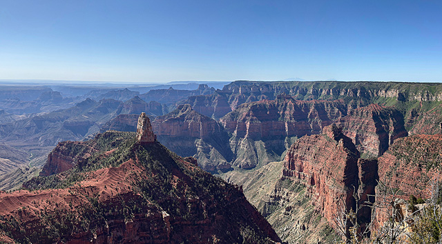
On our way out of the park, we took the road to Imperial Point - the highest point (elevation 8803 ft) on the North Rim. If we had had more time we really would have like to have seen the remaining overlooks on the Cape Royal Road.

View from Imperial Point.


Wednesday, June 18, 2025

Between the Rims

Sunday, 25 May 2025

There are no bridges across the canyon - to get from the South Rim to the North Rim requires a drive of almost 250 miles (Canyon Village to North Rim Lodge). We had to drive east and north to cross the Colorado River, then return west and south. But there are some interesting things to see along the way.

The San Fransisco Peaks, about 40 miles south of the park and about 10 miles north of Flagstaff, still had snow at the top.

Vermillion Cliffs as seen from Navaho Bridge.

Crossing the Colorado River at Navaho Bridge/Marble Canyon. Echo Cliffs are in the background.

Looking north from Navaho Bridge. Vermillion Cliffs are on the left, and Echo Cliffs are on the right.

Echo Cliffs as seen from Navaho Bridge.

At Cliff Dwellers, house-sized boulders have eroded from the cliffs and rolled to within feet of the highway. (In all honesty, the boulders probably predate the highway.)

Vermillion Cliffs: View from an overlook as US 89A climbs a substantial ridge. 

Tuesday, June 17, 2025

Grand Canyon National Park - South Rim

Saturday, 24 May and Sunday, 25 May 2025

The Grand Canyon is so immense that it's difficult to take it in. While each viewing point has similar views, the canyon definitely changes in character along its length. We only "sampled" a small section of the canyon - from Canyon Village in the west to Desert View in the east.

Part of the Bright Angel Trail. Impressive switchbacks! We were in no shape to do any serious hiking in the canyon. This trail drops at least 600 feet each mile. And as you descend, the temperature rises.

The Isis Temple formation as seen from near Canyon Village.

The distant mountains on the horizon are over 60 miles away. The fact that they were clearly visible meant that the air quality was quite good.

Plateau Point Trail. There's a glimpse of the Colorado River in the center of the photo.

Bright Angel Canyon

From left, mid-distance: Shiva Temple, Isis Temple, Cheops Pyramid.

From Mather Point.

From Mather Point - Bright Angel Canyon is towards the right.

Phantom Ranch - at the bottom of the canyon.

View from Grandview Point.

From Moran Point - note the tilted red layers - part of one of the "unconformities" (where millions of years are missing from the geological strata).

From Moran Point - this time the tilted layers are at the top of the canyon wall.

We thought that the views from Lipan Point were the best. There were good views of the river, plus you can see to the flat lands beyond the canyon to the east.

From Lipan Point - the treacherous Hanse Rapids are near the center of the photo.

View from Lipan Point.

Geology

The "Trail of Time" along the South Rim Trail between Verkamp's Visitor Center and the Geology Museum displays rock samples along a physical time line. The rocks have one side polished to bring out the structure and beauty of the rocks. There are several dozen rocks in the time line, I present four of my favorites below.

The metamorphic Vishnu basement rocks show evidence of extensive folding. 1.4 to 1.8 billions years old.

Hautata Conglomerate - 1.2 billion years old.

Supergroup Stromatolite - about 740 million years old.

Banded Spring Deposits (sorry - I lack notes on this one).


Monday, June 16, 2025

Yosemite National Park - Miscellany

Wednesday, 21 May, through Friday, 23 May 2025

What didn't fit in elsewhere.

On the side of Mirror Lake is a place where visitors stack stones to make precariously balanced cairns.
 
California Ground Squirrel at Happy Isles.

Most of the black bears (Ursus americanus) in Yosemite are actually cinnamon-colored. We came across this bear digging for grubs in a rotten log near Happy Isles Road. The ear tags and tracking collar show that this is a known bear.

Remants of a large wildfire near the beginning of Glacier Point Road.

As we left the park, there was a 2-mile long line to enter the park at the beginning of the Memorial Day weekend.


Yosemite National Park - Waterfalls

Wednesday, 21 May, through Friday, 23 May 2025

As glaciers grind their way down the mountains, the scouring to make U-shaped valleys leave a lot of "hanging valleys" at the former edge of the glaciers. These laid the ground (literally) for the spectacular waterfalls that cascade over the sheer cliffs of Yosemite. Meltwater from winter snows typically peaks in May, so we got to see the falls at their best.

Bridalveil Fall

Bridalveil Fall is the first prominent waterfall seen when entering Yosemite Valley.


Yosemite Falls

Yosemite Falls is farther up the valley and is visible from many locations. It has two main falls (upper and lower) with a cascade in between


A short trail leads up to the base of the lower fall. On a warm day, the mist is refreshing.

Upper fall.

Yosemite Falls as seen from Glacier Point.

Ribbon Fall


Horsetail Fall

Horsetail Fall, like many of the smaller waterfalls can be difficult to see at first. In the photo above, it's a white patch in the center of the photo, totally dwarfed by the mountains and landscape.

The waterfall is easier to see from other vantage points.

As seen with a telephoto lens (or binoculars).

Nevada and Vernal Falls

Nevada Fall (top) and Vernal Fall (bottom) as seen from Glacier Point.

The best view of these falls is from Washburn Point.

Vernal Fall

Nevada Fall

We think that this is brief glimpse of Nevada Fall from Happy Isles Road.

Sentinel Fall

Sentinel Fall