No Turn On Red

No Turn On Red

Friday, May 27, 2022

Erie Canal - Brockport to Weedsport

 Thursday, 12 May 2022 - Brockport to Bushnell's Basin (31.4 miles)

We rode from Brockport through Adams Basin, Spencerport, the outskirts of Rochester, and Pittsford to Bushnell's Basin. Lilacs were in full bloom, Rochester was in the midst of their annual Lilac Festival, and the International Lilac Society was holding their annual meeting in the Hampton Inn where we spent the night.

One of several "control structures" (dams that can be raised and lowered) used to regulate water depth and flow in the Canal.

A panoramic view of the Canal and the Genesee River where they meet in Rochester's Genesee Valley Park. We got somewhat confused by all the bridges and stream crossings in this area.

To say that Canada geese are not endangered is an understatement. All along the trail we saw lots of the "new generation". Once or twice geese got aggressive to trail travelers as they defended their space.

Another, somewhat smaller, goose family at the same spot (Curtis Point in Genesee Valley Park).

Friday, 13 May 2022 - Bushnell's Basin to Newark (26 miles)

A short day of riding from Bushnell's Basin through Fairport, Macedon, Palmyra, and Port Gibson to Newark.

All sorts of watercraft use the canal. In Fairport we saw several competitive rowers practicing.

We paused to watch the Sam Patch cruise by on its way to Pittsford to start the season.

The Sam Patch is a replica canal packet boat that operates out of Pittsford from late May through October.

Lock 30 on the modern canal near Macedon.

At Lock 30, we could walk across the lock gate.

The Aldrich Change Bridge in Palmyra-Macedon Aqueduct County Park has had a colorful history. Originally built in 1858 to span the Erie Canal in Rochester, it had been relocated twice (1880 and 1915) when it collapsed in an ice storm in 1996. Volunteers relocated and restored the bridge in 2002-2003. A "change bridge" was designed to let mules towing barges to change sides of the canal without having to unhook their tow ropes from the barge. Designed by noted bridge designer Squire Whipple, it is one of the earliest iron truss bridges.

A magnificent redbud in the gardens at Vintage Gardens B&B in Newark. While the grounds have shrunk considerably (although still substantial) this B&B was the original home of Jackson & Perkins - the rose growers now located in California.

Saturday, 14 May 2022 - Newark to Weedsport (34.1 miles)

As we rode from Newark to Weedsport, we passed through Lyons, Clyde, Savannah, Montezuma, and Port Byron. Between Clyde and Port Byron, we had one of the longest on-road sections - about 16 miles.

Much of today's ride followed the old, no longer used, Erie Canal. The modern canal follows a different path, mostly to the south. The photo above is of the old E54 lock between Lyons and Clyde.

The Centerport Aqueduct, just outside Weedsport, as seen from the old canal bed.

A view of the Centerport Aqueduct from the trail (along the right edge of the canal in the previous photo). The stone pillars held the towpath, while the horizontal stone "beams" held up a wooden trough that was waterproofed to hold the canal waters. Two or three of these old aqueducts have been restored and are used by tourist boats.

Niagara Falls

 Monday, 9 May 2022 (5 miles, walking)

We spent the afternoon walking along the Niagara River and viewing the falls from the American side. The Canadian side has better views of the falls, but (1) we didn't want to walk that far, and (2) we didn't bring our passports. Even so, we had a full afternoon of walking.

Niagara Falls State Park follows the Niagara River and includes all the islands on the American side. As the river approaches the falls, it picks up speed in impressive rapids.

Near the Three Sisters Islands - gulls like to perch on rocks and logs in the rapids.

The American Falls are in the foreground. Horseshoe Falls (Canadian Falls) are in the background - mist obscures most of the view.

Terrapin Point on Goat Island with lots of gulls flying around. Horseshoe Falls are in the background.

On a sunny day you can catch a rainbow in the falls.

The view of Horseshoe Falls from Terrapin Point - the best view you can get if you stay in the US. According to signs in the park, the Canadian Falls are more than 2 times as wide as the American Falls and have 9 times the flow.

To show how much better the view is from the Canadian side, here's a picture of the American Falls taken in July 1975 - recently digitized from my archive of 35mm slides. I know we visited in 1994 as well, but those must have been with color print film, and I haven't gotten around to digitizing those.

Erie Canal - Buffalo to Brockport

 Monday, 9 May 2022 - Buffalo to Niagara Falls (25.4 miles)

Our big bike trip of the year was to cycle the Erie Canalway Trail across upstate New York. The Canalway is part of the recently developed Empire State Trail - a network of trails that connects Buffalo to Albany, and Albany south to New York City or north to the Canadian border at Rouses Point. There are a number of side-trails as well, and we started with one - the Shoreline Trail that connects Buffalo to Niagara Falls.


Logistics: We spent Sunday night at the Marriott Courtyard Canalside in Buffalo. We dropped off our bikes and gear, then drove to the Buffalo International Airport to park our car in long-term parking for 12 days. We took public transit back to downtown Buffalo ($2 each - can't beat that fare!), so that we were ready for an early morning start.

"Cycling the Erie Canal" by Parks and Trails New York (www.ptny.org) was essential to this trip. It has detailed maps, and lots of information on hotels, B&Bs, bike shops, and points of interest. We picked up our copy on Amazon.


View of Lake Erie as we left Buffalo.

Windfarm along Lake Erie in Buffalo.

Peace Bridge connecting Buffalo to Canada.

Tuesday, 10 May 2022 - Niagara Falls to Lockport (30 miles)

We rode from Niagara Falls through the Tonawandas and Pendleton to Lockport.

Tonawandas Gateway Harbor - where the Erie Canal meets the Niagara River. For a brief period, Tonawanda and North Tonawanda were the "Lumber Capital of the World", thanks to the Erie Canal.

You can bike to a lot of places from the Harbor.

Paddlewheel on the Canal. It was still to early in the year for tour boats, but in several places the boats were being readied and checked out.

Lockport, looking east. The "Flight of Five" original locks are on the left. The modern set of two is on the right. Unlike locks along rivers, there is no need for a dam to level the river - just the locks.

Wednesday, 11 May 2022 - Lockport to Brockport (45.2 miles)

Today's ride was the longest of the trip. We rode from Lockport through Gasport, Middleport, Medina, Knowlesville, Eagle Harbor, Albion, Hulberton, and Holley to Brockport. Towns and villages are spaced roughly every 5 miles along the original canal.

Lockport - Locks that are part of the original "Flight of Five". While the entire Canal is considered an engineering marvel of the early 19th Century, the set of 5 locks at Lockport were the limiting factor. At Lockport the Canal rises 70 feet through the limestone of the Niagara Escarpment. Modern locks have replaced the five old ones with two modern ones. The group of volunteers who built a replica original canalboat were preparing to fill the old locks so that they could do maintenance after the winter.

"Lock Tenders Tribute" is a set of bronzes that re-create a classic photo of the lock tenders that worked 12 hours a day, 7 days a week, from April through November keeping boats and barges going through the Canal.

Western New York is a notable wine-producing region. I liked the contrast of the while grape flowers on the grapevines and dandelions blooming between the rows of grapes.

Typical canal scene on this part of the trail.

Medina (pronounced with a "long-I"). It was surprising to see a waterfall in the flat landscape. This creek runs through a culvert under the canal. 

The odd rash on my hand is sunburn through the crocheted backs of my old-fashioned bicycle gloves.

Tuesday, May 3, 2022

View to the East

 Our western view is obscured by Fore Mountain, so sunsets are not a great view. But our eastern horizon is mostly wide open, and sunrises can be spectacular.

Crepuscular rays and fall foliage.

Sunrise can be spectacular (if you get up early enough to enjoy it!).

A panoramic view of sunrise.

Dense fog in the valley.

Winter's Last Gasp

 Winter is now over - even spring is almost at its end - so here's a few winter pictures to remind me why I shouldn't complain about temperatures now hitting the high 80s (°F).

Snow in March.


While it wasn't much snow, it stuck to the tree branches and made for a nice contrast with the background pines.

One of my favorite phenomena: ice needles. Wet ground meets very cold air. (Previous posts here and here.

Wildlife - Mostly Birds

 I've been accumulating wildlife photos, so it's time for yet another wildlife post.

Cardinal in a red maple

Robin in a red maple

Red-tailed hawk (no questioning that ID!)

I got a chance to follow the red-tailed hawk for several minutes as it soared above the woods.

Our trail cam caught a white-tailed deer running.

Thursday, April 14, 2022

Callie Furnace

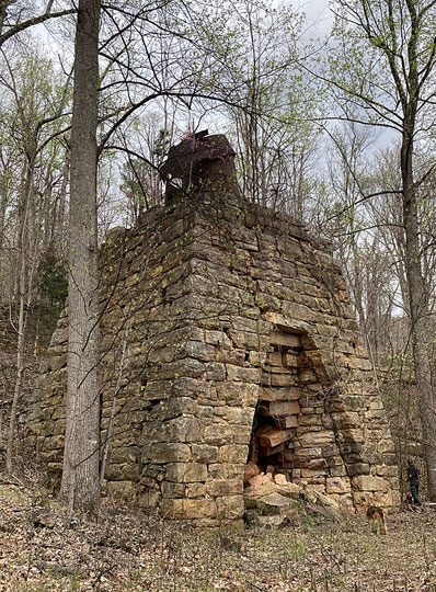
Callie Furnace is a late 19th Century iron furnace in northern Botetourt County, Virginia. It is accessible via an unmaintained road that connects Glen Wilton and Iron Gate. The road may be open during deer season (October-November), but is deeply rutted and pot-holed, and is best traveled on foot. Today, we approached from the Glen Wilton side. Maps (USGS topo maps, Google maps, and Apple maps) are highly inaccurate - so be warned!

This sign along the road tells you that the area is mostly used by hunters.

People will dump old tires any where in the National Forest. Since this road is behind at least two locked gates, it's mystifying how anyone could get the tires this far.

The site contains several structures. That's Lon at the left side of the furnace, which gives you some idea of the scale.

A closer view of the furnace.

At some point, two picnic tables had been added to the site, but as you can see, they aren't in very good shape!

The metal "deck" at the top of the photo covers a deep, brick-lined pit.

Slag from the furnace can be seen nearby.

It was a beautiful day, with redbuds at their peak.

An emerging buckeye leaf at the Callie Furnace site.

The colorful Birdfoot Violet (Viola pedanta) was a common sight along the road.

During World War II, Glen Wilton had an ammunition plant. It fell victim to a spectacular explosion in July 1942 - heard and felt for miles. Eventually, the remains of the ammunition plant were deeded to the US Forest Service, and a few remnants of the plant still exist.

These concrete "tombstones" at one time held tanks or pipes. Now they are being reclaimed by the forest.