No Turn On Red

No Turn On Red

Monday, December 20, 2021

Christmas Lights

 The Clifton Forge School of the Arts has illuminated the garden behind/between their buildings. Finally remembered to visit after dark tonight.

Looking into the garden from the entrance.

Looking back towards the entrance from the far end.

Looking back at the entrance.

Sunday, October 31, 2021

Skywatching

 Two unusual rainbows this week.

October 25: An afternoon rainbow to the east where you wouldn't even know it was raining if it weren't for the rainbow.

October 31: An unusual morning rainbow in the northwest. The fall colors have finally appeared - about two weeks later than usual.


Zinnias

I'm not particularly gifted at gardening. Sometimes I claim to have a "black thumb". But zinnias seem to be my sweet spot. Plant the seeds, give them a bit of water - especially in dry times, come back in two months and start cutting the blooms.

Not only are zinnias colorful, but pollinators seem to like them. Here you can see a bumblebee and two butterflies attracted to the flowers.

Common Buckeye butterfly (Junonia coenia)

Even at the end of October the zinnias are blooming. We're predicted to have a hard freeze several nights in the upcoming week, so this is probably the last of this year's zinnias.

Cut zinnias, along with sunflowers and daisies in a shallow bronze bowl from India.

Thursday, October 21, 2021

Katy Trail 4 - Wildlife

Truth be told, we didn't see any spectacular wildlife along the trail. This is high season for the Katy Trail and hundreds of bikes are on the trail. We saw many, many fox squirrels - even almost ran over one who couldn't decide which way to run and brushed against my wheels and leg. We also saw a few deer, turkey vultures, one red-tailed hawk, and a bird the size and perching style of an osprey, but it was eating carrion, so I doubt it was an osprey.

Geese flying over St. Charles.

Great Blue Heron in the river at Hermann.

Something likes to chew on the trail benches. Beaver? This was much more common on the western parts of the trail, but still could be seen every once in a while in the eastern reaches of the trail. We didn't notice any classical beaver sign (trees chopped off to a pencil point).

Katy Trail 3 - Hermann to St. Charles

 Monday, 18 October, and Tuesday, 19 October 2021

Hermann - Augusta - St. Charles

Hermann to Augusta: 37.5 miles. Augusta to St. Charles: 27 miles

We finished our ride with a moderate day and a welcome short day.

Looking upriver (west) from the Hwy 19 bridge at Hermann.

Lost Creek enters the Missouri River.

Augusta may be a tiny town (population less than 300), but it packs a lot into its small space. Along with about a half-dozen B&Bs there are two wineries and a brewing company in the town. For those with more transportation than a bicycle, there are many more wineries a short distance from town. Here I am tasting wine at the Augusta Winery - two short blocks from our B&B. We spent the night at the Lindenhof B&B, which has a fabulous backyard with fireplace, hot tub spa, and gardens. (The inside is very nice as well!) Augusta also has a first class gallery, Gallery Augusta. We're going to come back when we can carry a few items home in our truck - it's difficult to pack wine, furniture, and art on a bicycle!

One of the few places the bluffs were easily visible from the trail.

More highways, more bridges. This is the I-64 bridge over the Missouri River.

Backyard bee hives just outside St. Charles.

We made it! Our truck was waiting for us where we left it in the large municipal parking lot at the St. Charles trailhead. Total distance: 240 miles in 6 days. It's too bad we had to immediately start driving home without spending more time here. Not the least would have been to have ridden to the end of the Katy Trail in Machens, another 13 miles. If we could have stayed another day, we could have done the 26-mile round-trip and "rung the bell" in Machens. But other obligations awaited, and we drove the 12-hour trip back to Virginia.

Our trail/security camera caught the reflections from our bicycle tires as we finally made it home.

We enjoyed our time on the Katy Trail - especially the quirky, interesting towns along the trail. We've been spoiled by the outstanding scenery along other trails we've biked (GAP-C&O, Greenbrier River, Jackson River, Hiawatha, Mickelson). If you're looking for a scenic trail, there are better ones. Road noise was also annoying at times. But we had a great time riding through America's heartland.

Katy Trail 2 - Boonville to Hermann

 Friday, 16 October and Thursday 17 October 2021

Boonville - Jefferson City - Hermann

Boonville to Jefferson City: 53 miles. Jefferson City to Hermann: 47 miles

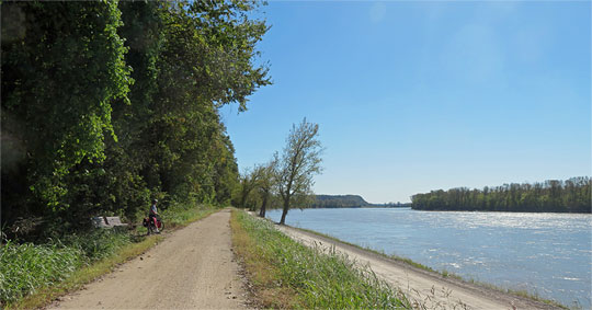
These were the longest days -- back-to-back 50 milers. I find riding 40 miles a day isn't bad, but 50s are not my choice. From Boonville the trail follows the Missouri River and is as flat as a trail can get. The surrounding area has bluffs and hills, but for a railroad, flat and straight is the ideal. The MKT (Missouri-Kansas-Texas) Railroad found that putting up with devastating floods was worth the cost and risk in service to flat and straight.

The first crossing of the Missouri River - and the only one on the Katy Trail itself - is leaving Boonville.


A flood in 2019 washed this bridge off its foundation. In dry times, trail users can ford the small creek and continue, but after four or five days of rain, there was water in the creek and we elected to take the official detour which was a not-very-pleasant 2-mile ride along US 40 (two-lane, no shoulders), followed by one mile along a small road leading to Rocheport.

By taking the detour, we missed the only tunnel on the trail, which is just outside Rocheport. It's a short tunnel - not that much longer than the culverts we road through.

The north side of the Missouri is lined with limestone and dolomite bluffs. Most of the time they are barely visible through the dense vegetation. There were many of these warning signs along the trail.

Lon's second flat of the trip - this time on the front tire. When checking the inside of the tire, the cause of the flat was obvious - a 1/2-inch long nail/tack/spike had gone completely through (inset photo).

Good views of the river were remarkably rare. If the trail ran close to the river, there was usually a fairly dense set of trees between the trail and the river. At other times, the trail could be a mile or two off the river - going straight where the river doesn't!

Coming into Jefferson City the capitol dome was visible above the farm fields.

It was a three-mile ride off-trail to get to our hotel, the Marriott Courtyard - definitely very modern.  An official spur trail leads from the Katy across the Missouri into town. The US 54 bridge has a dedicated pedestrian/bike lane, which is accessed by this amazing three-level ramp.

Lon riding up the ramp.

Sue riding down the ramp the next morning.

"Standing Rock" is a sandstone "plug" was left behind when the rest of the limestone bluff eroded away. Although the rock is a 1 1/2 miles from the river, at least 7 floods have been recorded here, some over half-way up the rock.

We never knew we had entered the nuclear power plant emergency planning zone.

Once again our night's destination, Hermann, was on the south side of the Missouri River. The two-mile spur was along a very busy road, but the shoulder was wide and there was a dedicated pedestrian/bike lane on the bridge. Our hotel for the night was the Hermann Crown Suites - a tavern with several B&B rooms, as well as a nice bar and performance space in the cellar. Hermann displays its strong German heritage with Octoberfest - food, beer, wine, and music.

Katy Trail 1 - Clinton to Boonville

We just completed a 6-day bike trip on the Katy Trail in Missouri. Overnight arrangements and shuttle from St. Charles to Clinton were arranged through Crossroads Bike Tours.

Thursday, 14 October and Wednesday, 15 October 2021

Clinton - Sedalia - Boonville

Clinton to Sedalia: 38 miles. Sedalia to Boonville: 38 miles

One mistake we made was starting the trail with an afternoon ride from Clinton to Sedalia. 38 miles doesn't sound that daunting, but ... we didn't leave Clinton until 1 PM; Lon had a flat tire immediately after leaving Clinton; after three days of rain, the trail was very soft, which made for tiring riding; and sunset was near 6:30 PM, so it was getting dusky as we got to our hotel in Sedalia. Next time we would spend the afternoon in Clinton, and get into Sedalia early enough to visit the museum.
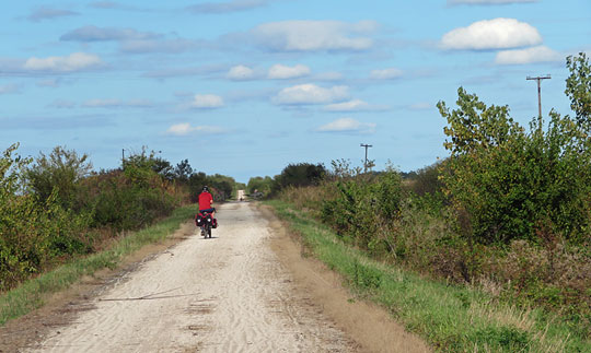
This part of the Katy Trail has small, but noticeable grades.

Typical trail landscape - lots of farms, mostly corn and soybeans.

Not too far from Sedalia, the trail reaches its highest point - all of 955 above mean sea level.

Lon and a railroad-themed sculpture at the Sedalia depot and museum. We arrived too late and left too early to visit the highly-recommended museum.

About half the time the trail was nicely shaded.

Sue on the bridge over the Lamine River.

This section of the trail had three large culverts.

One of the disappointments of the trail was how often we were paralleling and/or crossing 4-lane highways. This is I-70 just outside Boonville. Even some of the 2-lane highways were quite busy with traffic.

The final descent from Pilot Grove to Boonville (11.5 miles) was a welcome relief!

Our overnight accommodations in Sedalia and Boonville were charming old hotels: the Bothwell in Sedalia, and the Frederick ("The Fred") in Boonville. Both were a step back into the early 20th Century.

Friday, August 27, 2021

Lightning Gallery

Yesterday evening I took 30-second exposures as a thunderstorm approached. After watching for an hour and a half, it fizzled out less than a mile from our house.


Details on photos: Canon EOS 77D; Sigma 18-300 lens, set at 18 mm; f 5.6; 30 sec exposures.